

/https%3A%2F%2Fsportsmole-media-prod.s3.gra.io.cloud.ovh.net%2Fuploads%2F2026%2F07%2Fjude-bellingham-4-6a52c09b979bf543459404.jpg?w=1024&resize=1024,1024&ssl=1 "Preview: England vs Argentina – prediction, team news, lineups | World Cup 2026")


Video: Crews clear roads in Marshfield, MA during Winter Storm Hernando
Patriot Ledger staff photographer Greg Derr captured crews with Marshfield Department of Public Works clearing Furnace Street on Feb. 23, 2026 during Winter Storm Hernando.
(This story has been updated to reflect new information.)
As a blizzard continues to make its way through Massachusetts, snow is piling up, with the National Weather Service (NWS) recording over 30 inches in multiple towns.
Bristol County has seen the most accumulation, with the highest snowfall total at 33 inches in Dartmouth as of 4:30 p.m. and 31 inches in Somerset and Berkly as of 3 p.m. On the other hand, western Massachusetts has received the least amount of snow, with only 5 inches recorded in Southampton, Baldwinville and Pepperell.
While the Massachusetts snowfall totals have been and will continued to be updated at different times throughout the storm, here’s where they currently stand.
MA snow totals by town
Totals in inches; time recorded shown
33.0 inches
- Dartmouth — 33.0 in (4:30 p.m.)
32.0–30 inches
- Westport — 32.0 in (4:30 p.m.)
- Berkley (1 ENE) — 31.0 in (3:26 p.m.)
- Somerset (1 NE) — 31.0 in (2:12 p.m.)
- New Bedford — 31.0 in (5:28 p.m.)
- Hanson (1 W) — 30.0 in (2:00 p.m.)
- West Bridgewater (2 NNW) — 30.0 in (5:04 p.m.)
29.9–26.9 inches
- Whitman — 29.6 in (4:34 p.m.)
- North Scituate — 29.0 in (5:07 p.m.)
- Somerset (3 S) — 28.7 in (1:00 p.m.)
- Lakeville — 28.0 in (2:00 p.m.)
- Plymouth (1 NW) — 28.0 in (4:31 p.m.)
- West Wareham (3 NNE) — 27.8 in (4:08 p.m.)
- Dighton (3 WNW) — 27.1 in (12:30 p.m.)
- Taunton — 27.0 in (2:30 p.m.)
- Taunton (1 WNW) — 27.0 in (2:12 p.m.)
- Brockton — 27.0 in (2:00 p.m.)
- Middleborough (1 ESE) — 26.8 in (2:00 p.m.)
- North Scituate — 26.5 in (3:50 p.m.)
- NWS Boston/Norton — 26.3 in (1:22 p.m.)
- Norton — 26.0 in (2:00 p.m.)
- Acushnet — 26.0 in (12:48 p.m.)
- Abington (1 SSE) — 26.0 in (2:00 p.m.)
25–20 inches
- Stoughton — 25.0 in (3:45 p.m.)
- North Attleborough (1 SW) — 25.0 in (2:53 p.m.)
- Westport (4 SE) — 25.0 in (2:31 p.m.)
- Plymouth (1 NW) — 25.0 in (2:37 p.m.)
- Pembroke (1 WNW) — 25.0 in (2:00 p.m.)
- Foxborough (1 NNE) — 24.5 in (12:00 p.m.)
- Hanover (2 WNW) — 24.5 in (4:01 p.m.)
- Bridgewater — 24.0 in (3:23 p.m.)
- Kingston (1 SW) — 24.0 in (2:00 p.m.)
- Rochester — 24.0 in (2:00 p.m.)
- Pembroke — 24.0 in (12:30 p.m.)
- Attleborough (1 NNE) — 23.0 in (12:30 p.m.)
- Harvard (2 SSW) — 22.5 in (4:25 p.m.)
- Randolph (1 ESE) — 22.0 in (3:00 p.m.)
- Milton (3 SW) — 22.0 in (1:00 p.m.)
- Foxborough — 21.0 in (1:36 p.m.)
- Easton (2 W) — 21.5 in (12:15 p.m.)
- Centerville — 20.0 in (1:10 p.m.)
- Plymouth (1 ESE) — 20.0 in (2:15 p.m.)
- Rockland — 20.7 in (3:48 p.m.)
19.9–15 inches
- Norwood — 19.5 in (5:08 p.m.)
- Pocasset (2 ENE) — 19.5 in (1:41 p.m.)
- Norton (2 NNW) — 19.5 in (11:57 a.m.)
- Braintree — 19.5 in (12:10 p.m.)
- Millis (1 SSE) — 19.0 in (3:56 p.m.)
- Weymouth (1 E) — 19.0 in (11:46 a.m.)
- Milford (1 WNW) — 18.5 in (4:12 p.m.)
- West Wareham (3 NNE) — 18.6 in (12:16 p.m.)
- Scituate (1 NNE) — 18.0 in (2:00 p.m.)
- Rockland — 18.0 in (2:00 p.m.)
- Sagamore (5 N) — 18.0 in (1:32 p.m.)
- Milford (2 NNW) — 17.7 in (2:16 p.m.)
- Winchester (1 NE) — 17.6 in (5:08 p.m.)
- Winchester (2 W) — 17.0 in (4:06 p.m.)
- Wrentham — 17.5 in (12:00 p.m.)
- Concord (3 WSW) — 16.2 in (3:38 p.m.)
- Westwood (1 WSW) — 16.5 in (12:33 p.m.)
- Bellingham — 16.0 in (2:30 p.m.)
- Norfolk — 16.0 in (12:00 p.m.)
- Melrose (1 S) — 15.2 in (11:46 a.m.)
- Burlington (1 N) — 15.2 in (3:41 p.m.)
- Winchester (1 E) — 15.0 in (2:00 p.m.)
- Weymouth (2 NNW) — 15.0 in (3:12 p.m.)
- Yarmouth (1 WSW) — 15.0 in (2:00 p.m.)
- Acushnet (3 N) — 15.0 in (11:56 a.m.)
14.0–14.9 inches
- Watertown (1 N) — 14.0 in (12:00 p.m.)
- Sandwich — 14.0 in (2:00 p.m.)
- Cotuit — 14.0 in (12:15 p.m.)
- Sharon (2 N) — 14.0 in (2:00 p.m.)
- Whitinsville (1 NW) — 14.0 in (2:10 p.m.)
- Andover — 14.1 in (3:28 p.m.)

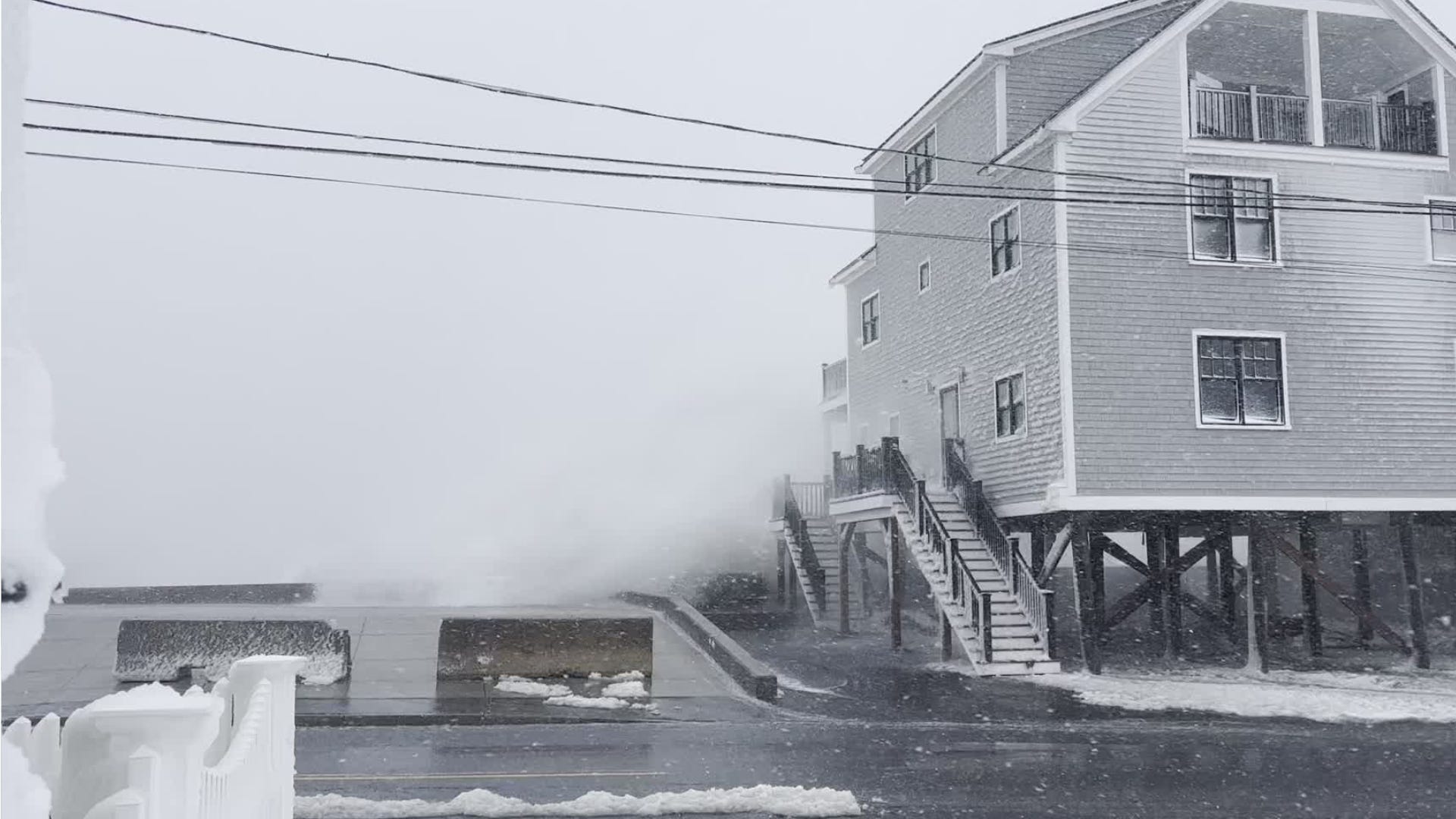
Waves crash over Brant Rock, Marshfield MA seawall. See the video
Patriot Ledger staff photographer Greg Derr captured Winter Storm Hernando conditions outside of Union Chapel in the Marshfield, MA on Feb. 23, 2026.
13.0–13.9 inches
- Worcester Airport — 13.7 in (3:47 p.m.)
- Medford (1 WNW) — 13.1 in (1:00 p.m.)
- Cochituate (1 SSE) — 13.0 in (3:33 p.m.)
- Woburn — 13.0 in (2:30 p.m.)
- Boylston (1 N) — 13.0 in (2:30 p.m.)
- Barre — 13.0 in (1:59 p.m.)
12.0–12.9 inches
- Lowell (2 S) — 12.9 in (3:02 p.m.)
- Cambridge (1 NW) — 12.5 in (1:26 p.m.)
- Rutland (1 N) — 12.5 in (2:30 p.m.)
- Northborough (1 SE) — 12.6 in (3:12 p.m.)
- East Douglas (1 NNW) — 12.7 in (12:17 p.m.)
- Waltham — 12.0 in (12:15 p.m.)
- Medfield — 12.0 in (12:00 p.m.)
- Norwood (1 NNW) — 12.0 in (12:00 p.m.)
- Milton (1 ENE) — 12.0 in (12:00 p.m.)
- Leominster (1 S) — 12.0 in (1:10 p.m.)
- Worcester (1 SSE) — 12.0 in (12:30 p.m.)
11.0–11.9 inches
- Arlington — 11.8 in (2:09 p.m.)
- Dracut — 11.0 in (3:12 p.m.)
- Hopkinton — 11.0 in (12:00 p.m.)
- Dover — 11.0 in (12:00 p.m.)
- Rockport — 11.0 in (12:14 p.m.)
10.0–10.9 inches
- Sudbury (1 NNW) — 10.6 in (2:00 p.m.)
- West Roxbury — 10.6 in (12:55 p.m.)
- West Roxbury (1 ESE) — 10.6 in (12:45 p.m.)
- Westford — 10.5 in (2:00 p.m.)
- Tewksbury (2 SW) — 10.5 in (4:32 p.m.)
- Sturbridge (1 NW) — 10.5 in (1:00 p.m.)
- Danvers (1 ESE) — 10.1 in (4:00 p.m.)
9.0–9.9 inches
- Townsend (3 NW) — 9.8 in (3:16 p.m.)
- Lexington (1 SW) — 9.5 in (2:59 p.m.)
- Chelmsford (1 E) — 9.5 in (2:00 p.m.)
- Methuen (1 N) — 9.0 in (2:00 p.m.)
- Ipswich (1 WNW) — 9.0 in (12:02 p.m.)
- Acton (2 E) — 9.0 in (2:00 p.m.)
- Watertown (1 W) — 9.0 in (1:16 p.m.)
- Wellesley (1 SSW) — 9.0 in (2:00 p.m.)
8.0–8.9 inches
- Tyngsboro (3 ESE) — 8.2 in (3:18 p.m.)
- East Dennis (2 S) — 8.5 in (2:00 p.m.)
- Maynard — 8.0 in (2:00 p.m.)
- Newburyport — 8.0 in (1:08 p.m.)
- Newburyport (2 SE) — 8.0 in (12:15 p.m.)
- Fiskdale — 8.0 in (2:30 p.m.)
7.0–7.9 inches
- Ashfield (3 SSW) — 7.5 in (4:08 p.m.)
- Warren (2 WNW) — 7.5 in (2:30 p.m.)
- Clinton (1 NNE) — 7.0 in (2:44 p.m.)
6.0–6.9 inches
- Orange (1 W) — 6.7 in (3:47 p.m.)
- Charlton (3 ENE) — 6.8 in (1:04 p.m.)
- Townsend (2 W) — 6.3 in (12:00 p.m.)
- Pepperell (1 WNW) — 6.2 in (3:52 p.m.)
- Newburyport (2 W) — 6.0 in (4:24 p.m.)
5.0–5.9 inches
- North Amherst (1 WNW) — 5.5 in (2:15 p.m.)
- Chatham — 5.5 in (2:00 p.m.)
- Ashby (1 WSW) — 5.3 in (12:46 p.m.)
Below 5 inches
- Leyden (2 N) — 3.8 in (1:00 p.m.)


